Remediation Site Descriptions
By 1892, five of the petroleum refineries in the Greenpoint area (Central Refining, Washington Oil Company, Kings Company Oil Refining, Empire Refining Company, and The Deove Manufacturing Brooklyn Oil Works) were purchased and became known as the Standard Oil Trust. In 1911, the Standard Oil Trust was dissolved and these properties became the Standard Oil Company of New York (SOCONY) and by 1929, had expanded to over 79 acres along Newtown Creek, including the property currently owned by KM. In 1931, SOCONY merged with the Vacuum Oil Company, which later became Mobil, and now is known as ExxonMobil. ExxonMobil ceased its refining operations in 1966, and in 1968, sold a portion of their property to Amoco Oil Company (Amoco) (which became BP and is now owned by KM) and other entities. Following the discovery of petroleum products seeping into Newtown Creek in 1978, ExxonMobil began to investigate and remediate the plume, and by 1993, had discontinued all fuel operations on the terminal property. In 2007, ExxonMobil removed the empty aboveground storage tanks associated with its former refinery operations, and from 2008 to 2012 excavated and removed more than 100,000 feet of underground piping from the former Brooklyn Terminal property.
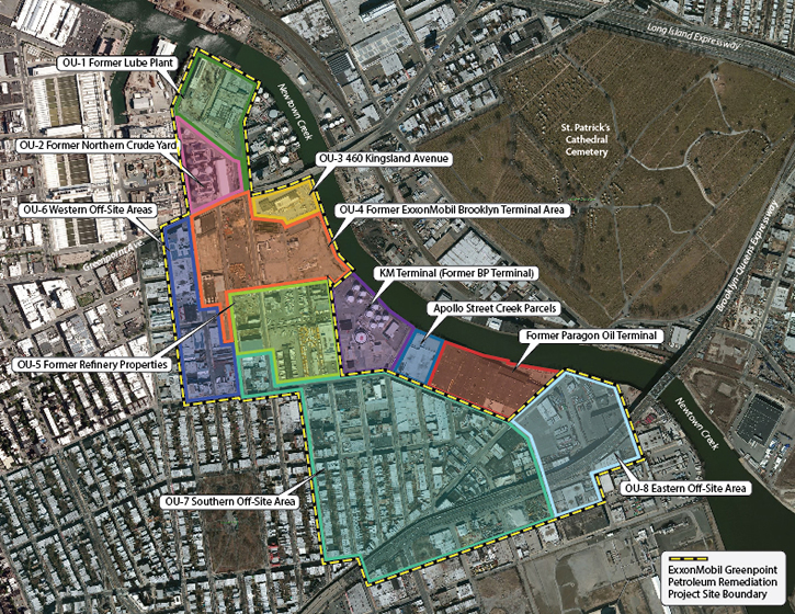
The original consent agreement between ExxonMobil and the NYSDEC was developed in 1990. In 2010, ExxonMobil signed a new consent agreement with the NYSDEC wherein they assumed responsibility for the remediation efforts within the historical footprint of the Greenpoint Petroleum Remediation Project, excluding the areas of the KM Terminal, Former Paragon Oil Terminal, and Apollo Street Creek Parcels. ExxonMobil’s responsibility includes an area of approximately 174 acres and typically referred to as the EM Decree Site on project figures (shown as a yellow and black line on figures). Based on the size, complexity, and variation of conditions across this area, the ExxonMobil site has been divided into eight geographically-based operable units (OUs) discussed in the revised Conceptual Site Plan (CSP) submitted in 2012. An operable unit is a portion of a remedial program that for technical or administrative reasons is addressed separately to investigate or cleanup site contamination. The approximately 62-acre portion of the site where ExxonMobil historically conducted petroleum operations consists of OU-1 through OU-5. A short description of these OUs is presented below:
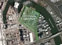 OU-1 (Former Lube Plant): This approximately 7-acre area in the northernmost portion of the Greenpoint Petroleum Remediation Project was part of the former Mobil Brooklyn Refinery. This property is identified as Block 2517, Lot Nos. 27, 35 and 40, based upon New York City records. OU-1 housed the Grease and Compounding Works (also known as the Former Lube Plant) for SOCONY, which manufactured grease, oil blending, compounding, and specialty products. Investigation activities performed from 1979 to 1980 identified measurable free product in 18 of 46 monitoring wells installed in the area, with an unknown volume of free-product removed from recovery well RW-7. ExxonMobil discontinued remediation operations of the Former Lube Plant and sold the property in 1985. Based on the site investigation for OU-1 and that the only potential petroleum-related impacts were observed within the historic fill material that comprise the shallow aquifer, the NYSDEC’s March 2016 Decision Document required three remedies for OU-1: the installation and maintenance of a site cover system (comprised by buildings, pavement, sidewalks, or one foot of soil cover) to eliminate the possible of surface exposure; perform Monitored Natural Attenuation (MNA) to demonstrate degradation of petroleum material in the subsurface; and the establishment of institutional controls and implementation of a Site Management Plan (SMP) for the property. A Final Engineering Report (FER) that documented construction of the OU-1 site cover system and the implementation of an Environmental Notice as an Institutional Control was submitted to the NYSDEC and approved on February 5, 2021. In accordance with the NYSDEC approval letter, MNA sampling events are conducted on an annual basis and vacuum truck recovery is performed at OU-1 monitoring wells when free-product thickness greater than 0.01 feet is detected.
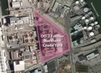 OU-2 (Former Crude Yard): Operable Unit 2 (OU-2) is located within the ExxonMobil Historic and is currently owned and operated by the New York City Department of Environmental Protection (NYCDEP), as part of the Newtown Creek Water Pollution Control Plant (WPCP).
OU-2 is located between Kingsland Avenue to the north and east, Greenpoint Avenue to the south and North Henry St. to the west and corresponds to the area historically known as the Former Northern Crude Yard portion of the former Mobil Refinery and Terminal. OU-2 is identified on New York City tax maps as Block 2527, Lot 2. The Metro Fuel Oil Terminal borders OU-2 to the east, the WPCP borders OU-2 to the west, and the Former ExxonMobil Terminal borders OU-2 to the south (OU-4).
Within OU-2, approximately 59,656 gallons of PSH were recovered between 1979 and 1997, through a number of efforts, by Mobil Oil Corporation.
Construction performed between 2001 and 2005, required the installation of watertight sheeting around the perimeter of the six-acre property to depths of 45 ft bgs; this sheeting remains in place. Following installation of the perimeter barrier, an extensive dewatering system was installed followed by the excavation and offsite disposal of approximately 257,875 cubic yards of soil. The soil excavation was completed to approximately 30 ft bgs across the entirety of OU-2. Excavated soils were replaced with fill material capable of providing a structurally suitable base for the concrete foundation of the solids-handling complex.
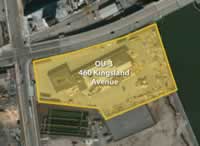 OU-3 (460 Kingsland Avenue): This approximately three and a half-acre area of the former Mobil Brooklyn Refinery is located immediately south of Greenpoint Avenue and east of Kingsland Avenue. Prior to 1892, this area was primarily undeveloped marsh land that was filled and used by both the Columbus Distilling Company and ExxonMobil’s predecessors until 1920 when the entire property was used for refinery operations. The property primarily served as a petroleum bulk storage yard that also had a concrete pit structure known as the TSD Blending Plant, which was in operation from 1954 to 1961. ExxonMobil sold the property in 1967, and the property has been redeveloped for various uses since that time.
An Alternatives Analysis Report (AAR) for OU-3 was submitted to the NYSDEC in August 2017, a revised AAR for OU-3 was submitted in February 2018 to address NYSDEC comments. A Decision Document was issued by the NYSDEC in August 2019. In accordance with the Remedial Action Work Plan (RAWP) approved by NYSDEC in April 2021, MNA sampling events are conducted on a semi-annual basis.
Separate from the petroleum related remediation efforts, ExxonMobil entered into a Consent Order with the NYSDEC in March 2016 for the voluntary remediation of polychlorinated biphenyls (PCBs) not attributable to ExxonMobil historical operations. A Remedial Action Work Plan was submitted to and approved by NYSDEC in February 2019, with the final voluntary remediation Consent Order with the NYSDEC approved in May 2019. Remedial activities began in the fall 2019 and were completed in early 2021. A Final Engineering Report is currently being prepared by ExxonMobil.
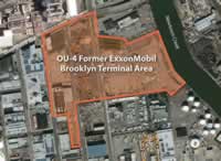 OU-4 (Former ExxonMobil Brooklyn Terminal): This approximately 18-acre area is currently owned by ExxonMobil and was considered the main plant area for the “Former ExxonMobil Brooklyn Terminal”. This OU is comprised of three parcels that are known as Kingsland Yard, Monitor Yard, and North Henry Yard. Refinery operations were present from the late 1800s until the late 1960s when OU-4 was operated as a petroleum bulk storage terminal until operations ceased in 1993. One of ExxonMobil’s two groundwater treatment systems is located on the Kingsland Yard parcel and is known as the ExxonMobil Terminal Recovery and Containment System (RCS). The RCS has a capacity to treat up to 450 gallons per minute of groundwater and currently receives groundwater from eight recovery wells located within OU-4 and OU-5 as well as five recovery wells from the Off-Site Plume Area (OU-7). The effluent (treated groundwater) is discharged to Newtown Creek through a State Pollutant Discharge Elimination System (SPDES) permitted outfall located off the 400 Kingsland Avenue (Kingsland Yard) property.
In 2018 ExxonMobil completed the installation of a new stormwater drainage piping system on the property, as well as relocated and enlarged the RCS effluent discharge pipe to enable the outfall to accommodate current and expected future flow of water from the Kingsland Yard property. ExxonMobil also modified the bulkhead to ensure a watertight seal between the new pipe and the bulkhead.
An updated revised OU-4 alternatives analysis report (AAR) was submitted to the NYSDEC on December 21, 2021, with the on-going product recovery activities within OU-4 are considered Interim Remedial Measures (IRMs) until the selected remedial approach is identified in a NYSDEC Decision Document.
In 2024, a total of approximately 198 million gallons of groundwater was treated by the RCS, while over 6,939 gallons of product was recovered by the seven RCS recovery wells located in OU-4, OU-5, and OU-7.
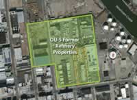 OU-5 (Southern Refinery Properties): OU-5 is comprised of six properties located between OU-4 and Norman Avenue, and is the southernmost part of the Historical Footprint portion of the Site. This group of properties is bounded by all or part of the western border of the KM Terminal, the southern border of the former Brooklyn Terminal, Norman Avenue and Monitor Street.
Portions of OU-5 were operated as part of the Former Brooklyn Refinery from the late 1800s to approximately 1969, when refinery operations ceased. Based on historical information, refining structures were primarily located within the properties west of Kingsland Avenue and across the central portion of OU-5 to the east of Kingsland Avenue Storage tanks were generally located in the southern portion of OU-5, east of Kingsland Avenue. The northern properties to the east of Kingsland Avenue were used for a combination of storage and refining processes.
back to top
ExxonMobil Off-Site Plume Area (OU-6, OU-7, and OU-8)
In accordance with the 1990 consent agreement between ExxonMobil and the NYSDEC, ExxonMobil accepted responsibility to delineate and remediate the portion of the free-product plume outside of the Former ExxonMobil Terminal properties, excluding that underlying the KM Terminal. This area became known as the ExxonMobil Off-Site Plume and generally consists of the areas south of Norman Avenue and west of Bridgewater Street. Free product beneath this area is the result of petroleum products spilled from the former refinery properties and other unknown releases and that flowed southward under the influence of pumping municipal wells near the center of Brooklyn prior to 1950. The Off-Site Plume area is largely commercial, but does include a portion of the residential area south of Nassau Avenue. This approximately 112-acre area consists of OU-6 through OU-8. A short description of these OUs is presented below:
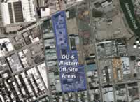 OU-6 (Western Off-Site Area): This approximately 18-acre area is comprised of approximately 33 commercial and industrial properties west of the former ExxonMobil Brooklyn Refinery. OU-6 was not part of the historical petroleum refining activities and is located outside of the historical footprint of the free-product plume. OU-6 was included as part of the 2010 consent agreement because this area was not thoroughly investigated before the consent order. The site investigation activities at OU-6 indicate the presence of limited contamination unrelated to ExxonMobil’s historic operations in Greenpoint. The NYSDEC proposed No Action as the remedy in the OU-6 Decision Document, dated March 2016. A site management plan (SMP) for OU-6 was approved by the NYSDEC in February 2017.
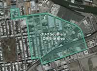 OU-7 (Southern Off-Site Area): This area is comprised of approximately 73 acres located outside of the historical refinery footprint and to the south of OU-5. This portion of the site was never owned or operated by ExxonMobil. OU-7 consists of numerous properties and land use throughout the majority of OU-7 is mixed industrial and commercial, except for primarily residential land use in the southwestern portion of the OU.
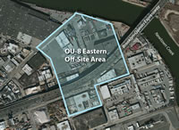 OU-8 (Eastern Off-Site Area): This approximately 21-acre area is comprised of numerous commercial and industrial properties southeast of the former Mobil Brooklyn Refinery. ExxonMobil never owned or operated petroleum activities on any of the properties within OU-8, but the free-product plume has extended beneath OU-8. OU-8 is considered off-site due to the extensive historical free-product recovery that has occurred and the lower volume of free-product accumulation that has occurred compared to OU-7.
The product recovery system for the ExxonMobil Off-Site Plume area includes 15 dual-phase recovery wells located throughout OU-7 and OU-8. Groundwater from 10 of these Off-Site recovery wells is treated at the ExxonMobil Off-Site Free-Product Recovery System (ORS) located at the corner of Bridgewater Street and Meeker Avenue (OU-7). Groundwater from the remaining five recovery wells is at the ExxonMobil RCS (OU-4). The effluent from the ORS is discharged from a SPDES-permitted outfall located at the end of Meeker Avenue into Newtown Creek (OU-8). In 2012, ExxonMobil installed gabion baskets around the off-site effluent discharge location to help prevent erosion of the Newtown Creek bank.
In 2024, a total of approximately 174 million gallons of groundwater was treated by the ORS and a total of approximately 3,475 gallons of product was recovered from beneath the Off-Site Plume Area.
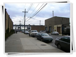
OU 7 - View of off-site treatment system building
back to top
KM Terminal (Former BP Terminal)
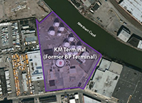 The KM Terminal property, located at 125 Apollo Street, is bordered by Newtown Creek to the north, Apollo Street to the east, Norman Avenue to the south, and Long Island Carpet Cleaners and various other industrial/commercial businesses to the west. The property was part of the former Brooklyn Terminal refinery operated by ExxonMobil and its predecessor companies until Amoco Oil Company purchased the property from ExxonMobil in 1968. Amoco constructed and began operating a fuel bulk storage facility in 1970 that still operates today. The KM terminal property is approximately 10 acres and has 11 aboveground storage tanks and one underground storage tank, with two loading racks. The storage capacity of the terminal is approximately 5,900,000 gallons and has been used to store diesel fuel, #2 fuel oil, kerosene, gasoline, and ethanol. Amoco Oil Company was renamed BP Amoco in 2000, and in 2008 became known as BP. On February 1, 2016 BP sold the terminal to Kinder Morgan and the facility is now known as the KM Terminal.
BP first installed a remediation system in 1980 to begin to recover product from historical refinery operations. The current KM Terminal product recovery system includes 13 dual-phase recovery wells located throughout the Terminal. Temporary product recovery is also occurring at one monitoring well (OW-11) where persistent LNAPL thicknesses greater than 3 feet have been observed. Groundwater extracted from the recovery wells is currently pumped to KM’s treatment system, which was put into operation December 2014.
In 2024, Kinder Morgan reported a total of approximately 12.6 million gallons of groundwater recovered by KM wells was treated by the on-site treatment system, and a total of approximately 21,305 gallons of product was recovered from beneath the KM Terminal property.
back to top
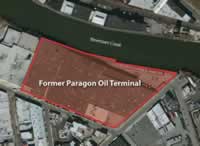 The former Paragon Oil Terminal property is located at 16, 42, and 50 Bridgewater Street and is bordered by Newtown Creek to the north, Meeker Avenue to the east, Bridgewater Street to the south, and the Apollo Street Creek parcels to the west. Beginning in 1886, two companies operated on this property: the Locust Hill Refining Company and Greenpoint Oil Refining. Both of these companies ended operations by 1905. From 1905 to 1921, a portion of the property operated as a cement works company. By 1929, a portion of the property was being operated as a petroleum storage terminal by Supreme Oil, which later became known as the Petroleum Terminal Corporation.
The other portion of the property was privately owned until 1928 when it became the Brooklyn Ash Removal Company. In 1934, all operations throughout the entire property were either run by, or affiliated with, the Paragon Oil Company, which operated the site as petroleum storage terminal for fuel oil (numbers 2, 4, and 6), lube oil, gasoline, diesel fuel, and kerosene. Paragon Oil was purchased by Texaco Oil, now is now known as the Chevron/Texaco Corporation, in 1960. The property was sold to Peerless Importers (now known as Empire Merchants) in 1968, which currently operates the property as a liquor distribution warehouse. According to a 2005 consent agreement with the NYSDEC, Texaco is responsible for delineation and remediation of the portion of the free-product plume underlying the Former Paragon Oil Terminal and to control seepage of petroleum into Newtown Creek at this location.
In 2004, over 400 feet of the concrete bulkhead along Newtown Creek was replaced with a steel bulkhead and a grout wall was added in 2006. In 2008, Texaco rehabilitated the Apollo Street Creek Parcel bulkhead and applied a sealant to the seams of the existing steel bulkhead in the area of product recovery to minimize product seepage into the creek. In addition to the bulkhead upgrades, Texaco also maintains “globe” boom containment along both Newtown Creek bulkheads to contain any product that may escape from landside. The amount of product observed inside the containment booms has significantly decreased over time due to the bulkhead upgrades and the total fluid product recovery well system discussed below.
back to top
Apollo Street Creek Parcels
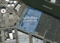 The Apollo Street Creek Parcels are located at 100-120 Apollo Street and are bordered by Newtown Creek to the north, the former Paragon Oil terminal to the east, Bridgewater Street to the south, and the KM Terminal to the west. Unlike the surrounding properties, there is no known history or evidence that petroleum refining or distribution operations ever existed on the Apollo Street Parcels. Significant fill was added to the eastern portion of the site in the late 1800s to fill tidal wetlands and create additional land. Various private citizens owned the property until it was purchased in 1926 by the Brooklyn Ash Removal Company. In 1933, NYC acquired the property and operated a trash incinerator until 1965 when operations ceased, likely the result of public complaints against dust and odor, as evidenced by newspaper articles from the time. In 1968, the Bridge-Apollo Company purchased the property, but by the mid-1980’s, the two lots comprising the Apollo Street Creek Parcels were under separate ownership. In 2000, Apollo Steel, LLC (Steel Equities) purchased both lots, leasing them to Empire Merchants for warehouse operations.
In 2007, the NYSDEC conducted a Remedial Investigation (RI) and Remedy Selection (RS) on the Apollo Street Creek Parcels. The purpose of the RI/RS was to assess the distribution of contamination at the site and develop a proposed remedial method for the free-product beneath the site.
On May 15, 2009, NYSDEC and Texaco entered into an administrative order which expands the efforts to address contamination at both the Former Paragon Terminal and Apollo Street Creek Parcels. Under the administrative order, Texaco agreed to address contamination beneath the Apollo Street Creek Parcels site, even though Texaco never owned or maintained operations at this property. A Decision Document was issued by DEC in June 2014 documenting the Department’s long-term remedy for both Former Paragon Oil Terminal and Apollo Street sites.
back to top
Former Paragon/Apollo Street Product Recovery System
The Texaco product recovery system in 2021 includes 16 total fluid recovery (TFR) wells located along the Former Paragon Oil Terminal and Apollo Street bulkheads. The total fluid pumps bring both product and water from the subsurface to an oil-water separator. Product is stored in an aboveground storage tank while groundwater is pumped through a treatment system and discharged to the combined sanitary sewer system via a NYC Department of Environmental Protection discharge permit. The existing recovery system was shut down in April 2018 to install the new groundwater treatment system upgrades and the TFR system resumed operation in February 2019.
The TFR system previously discharged treated groundwater under an existing New York City Department of Environmental Protection (NYCDEP) dewatering permit to combined sewer. However, Texaco applied and was issued a State Pollutant Discharge Elimination System (SPDES) equivalency permit to discharge to Newtown Creek by NYSDEC on April 1, 2021.
In 2024, approximately 8.9 million gallons of groundwater was recovered by the total fluid recovery system and a total of approximately 5-gallons of product was recovered from beneath the Former Paragon Oil Terminal and Apollo Street Creek Parcels.
back to top